

There are two hikes that I wanted the most to do during this Argentina and Chile trip. The first was the hike to Base las Torres in Torres del Paine National Park, and the other was the hike to Laguna de Los Tres (Mount Fitz Roy). While Both mountains are located in Patagonia, the base Torres is on Chilean side, and Mount Fitz Roy is on Argentinian Side. I included hiking Mount Fitz Roy on my 5-days itinerary in Argentina and I hiked it on the fourth day.

Table of Contents
Where is the location of Laguna de Los Tres and Mount Fitz Roy ?
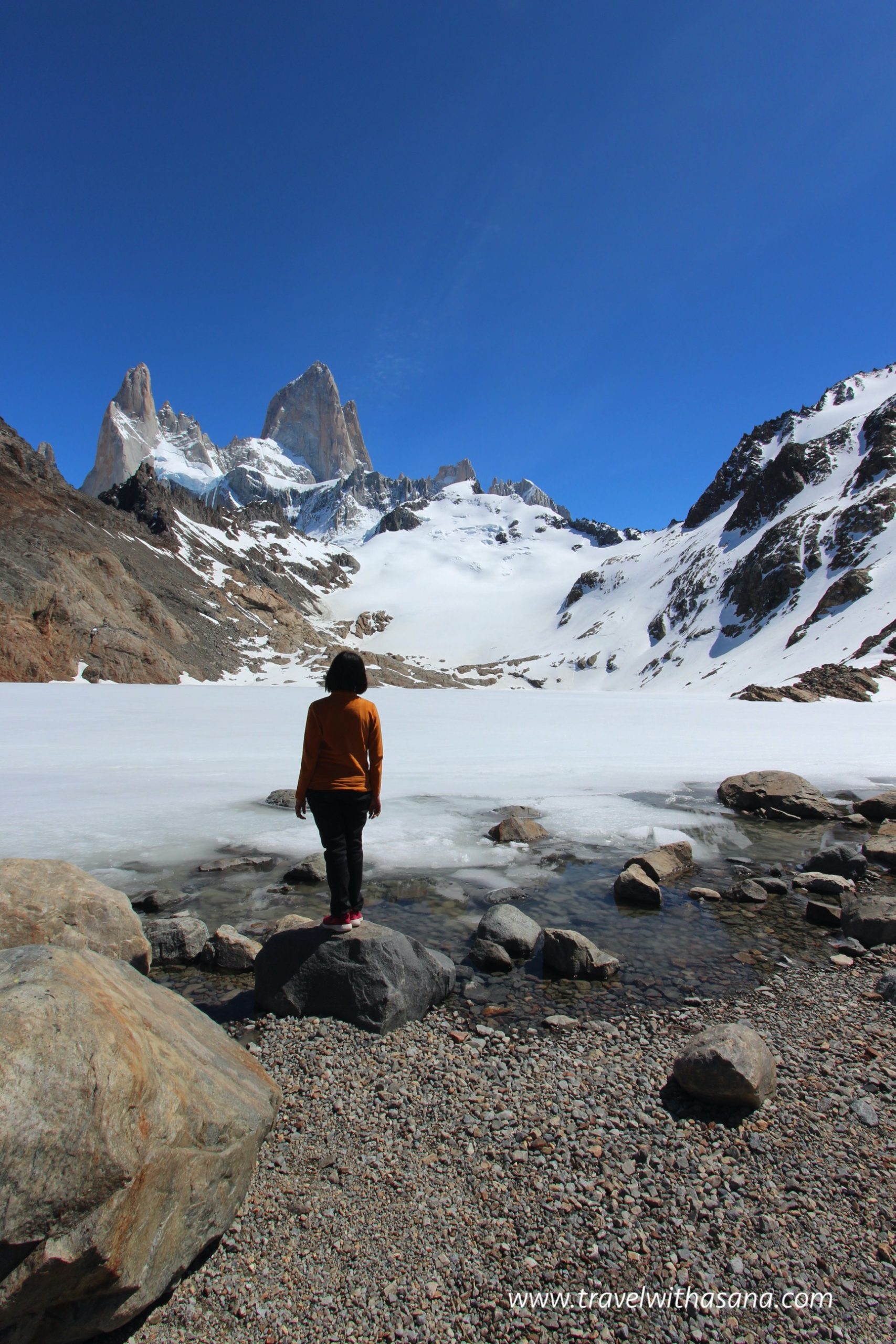
Mount Fitz Roy is located in Los Glaciares National Park, and the peak can be seen from the nearest city El Chalten. In fact, the starting of the hike (the trail head) is at the end of the Avenida St Martin, the main road in El Chalten. The hike to the mount Fitz Roy usually ends with the best view of Laguna de Los Tres, with the background of the peak of Mount Fitz Roy. “Los Tres” means three peaks that we see in the background, they are Fitz Roy (3405 m), Poincenot (3002 m), and Saint-Exupery (2558 m).
How to Get There
The trail head, like I mentioned before, starts at the small city of El Chalten. Unfortunately, there is no airport in El Chalten, and the closest airport is in El Calafate. A day before the hike, I flew from Buenos Aires to El Calafate and spend one day in Perito Moreno Glacier, before catching bus in the afternoon to El Chalten.


If you rent a car, it is definitely easy and flexible for you to reach El Chalten. It’s 4 hours drive from El Calafate and said to be the most beautiful route (Ruta 40). As you approaching El Chalten, Mount Fitz Roy and Cerro Torre will be seen from the road. There is also parking lot in the trail head if you want to leave your car there before the hike.
You can also use bus services regular from El Calafate to El Chalten. I booked the bus through Chalten Travel for 800 ARS (152,000 IDR/10 USD). The other companies are CALTUR and Taqsa. During the peak season, it is better to book the ticket online in advance.
The map of El Calafate Bus Terminal
El Chalten Bus Terminal
The Hike
There are actually many day hikes from El Chalten (source: Swoop Patagonia)
- Laguna Torre (Cerro Torre) hike. The climb is 250-350 meters, with 20 km duration (5-6 hours)
- Loma del Pliegue Tumbado. The final hike reaches 1000 meters above the city of El Chalten. The duration is 6-8 hours for 16-18 kilometers.
- Laguna de Los Tres (Mount Fitz Roy) hike. It’s a 7-10 hours hike for 22 kilometers distance. You’ll be seeing Laguna De Los Tres at the end of the hike, Laguna Sucia, and Laguna Capri.
My cousin and I decided to have a guided tour as we are unexperienced hiker. And so we booked through Grayline.
We were picked up at 8 am and rode a car to the trail head. Our guide was very kind and understanding. So, it was the best hike, although there were some dramas I will tell you about 😉
Overview
After experiencing it, I believe you need to be extremely fit to be able to finish the hike, especially the last one hour (for me it took two hours!!!) which gained steeply 400 m elevations with rocky path through and through. The rest of the trail were actually pretty easy to moderate, except the few kilometres at the beginning. However, after passing the last push of ascending trail, all my tiredness soon fade away, replaced by wonder and satisfaction.
From the trailhead in El Chalten, it’s 12 kilometers towards the Lagoon, and then another 12 km back, so that’s 24 kilometers in total with overall elevation gained +/- 800 meters.
KM 0-3
Elevation Gained: 350 meter with steady ascend
The first two kilometers of the hike felt quite hard and gained about 350 meters. There were few good view of the landscape but nothing notable. Trail path was vary, passing the forest with mystical branches spread around it. You can see the elevation profile of the hike here and here.


KM 3-9
Elevation Gained: +/- 0 meter
Gladfully, the next 5 kilometers up until Camping Poincenot was quite flat with some beautiful point of the Fitz Roy Peak.


I’m not sure where the drama of the hike started, but pretty sure it was when I charged towards while my guide and my cousin walked behind. I kept moving forward to the point where I waited for 20 minutes but I still could not see my guide nor my cousin. Meanwhile, I was afraid if I were not to move forward, I would likely not making it to the top on time. So, I decided to push forward.
After making it to Camp Poincenot, I took about half an hour bathroom break and searched for a drink. Still I did not meet my cousin and my guide. Knowing that I were close to the Laguna, I kept moving forward in the hope I can catch them on my way back.

KM 9-12
Elevation Gained: 400 meter steep ascent with rocky path
10 minutes ascend to the rocky path, I felt like giving it up. I was at one point where my drink was depleted. I filled my bottle along the way twice from the creek and river that I passed (there is no contamination in Patagonia, you can freely refill your bottle from wherever lagoon/creek you find along the hike). However, it was not enough. My mind and my leg were numb, I felt tired to the bone, and my bottle was empty. I let so many hikers before me to pass through, and even asked several of them some water they were extremely kind to share.
Looking back, there were few things that made me exhausted more than I could anticipated. First, that day i did not travel light when doing the hike. One day before, my luggage was stranded in El Calafate airport due to ground crew strike and I got a bulk of clothes and some overnight necessities with me just in case the luggage did not arrive on time (things which I was correct and anticipated). But, since I had to catch another bus back to El Calafate on the hiking day at 6 pm, I had to bring all that bulks on my backpack and this added unnecessary weight to the already bulky backpack up to the Laguna de Los Tres 🤦🏼♀️😅
The other thing that made the whole thing more miserable, was that my hiking shoes was on THAT luggage ( THE luggage that was stranded in El Calafate Airport). Yes, I hiked using regular sport shoes which did not help at all, especially during the last 2 kilometers and 400 m ascend on an extremely rocky and unstable ground. Third, I refused carrying my guide’s trekking pole (I didn’t know we were going separate ways!). Those three logistic issues, combined with my wariness about not meeting my guide and my cousin, made the hike more terrible than it already had 😔


THE PEAK ! 🎉🎉🎉
I did eventually reached Laguna de Los Tres (which I kept dreaming about for a good one year then) in two hours (two times of what regular trekkers would have, from the beginning of the steep ascend). But, that didn’t matter at all in the end. All the sweat, the shaky legs, the wariness, the thirstiness, all paid off and healed at once when I set my foot on the lips of the lagoon. The view was too surreal, it was too magical, too perfect, too unbelievably good, and too much of too many good things.
I ate my packed sandwich and refill my water bottle from the lagoon. The lagoon was actually still frozen, but I found some spots where the ice thawed and refill my bottle with it. There were actually two lagoons: the main and the grand lagoon, which is Laguna de Los Tres, and Laguna Sucia. I didn’t have the energy to walk to Laguna Sucia though it was just meters away. A single female traveller encouraged me to check that lagoon but I just didn’t have energy left to see it. I took another minutes to rest my feet before start going back.


KM 12-24 (Going back to El Chalten)
Elevation gained: -800m
There was actually two route in which you can go back to El Chalten. The first one is the same route through camping Poincenot, and the other route via Mirador. I took the later and surprisingly pretty far and quite path where I met almost nobody.

However at a point, I met a group of trekkers and the guide ask my name was Asana. I answered yes, and she said she got message from my guide that he waited at the beginning of the trek. A good feeling started to rise. But, I realized it was already 4 pm and I was still 10 kilometers away from El Chalten. There was no way we could chase the bus to El Calafate.
About half way to El Chalten, my phone got strong signal and a message from my cousin came in, saying that my guide was in rage! He worried about my wellbeing and all. I replied that I was okay and walking my best to coming back to the city. Surprisingly, the last 10 kilometers felt way more heavy and dull (though the route was easy), A toxic combination added with weariness and thirstiness (I got no water left on my bottle and I passed no creek/lagoon on my way back).
When I was just few meters away to the finish line, my guide met me with probably the angriest face I had known so far in my life. Even my mom never been mad at me that bad. But, I understand fully of my mistake (for not waited long enough) and made him worried sick. There was no signal at all after the first 5 kilometers so we had no way of communicating. I explained to him why I moved forward and he understood at the end. It was all good and everyone Happy 🎉


Summary/Lesson Learned
It was probably the best hike I have ever head in my life, despite all the difficulties I endured during the hike. In fact, all the difficulties make the experience worth it. I just wished I had ways to communicate to my guide and let him know I was okay to erase his wariness.
Me and my cousin eventually missed the bus and had to book private transfer to El Calafate, but we were all went happy from the experienced we had from the trek.
Just a few tips if you are to hike this mountain:
Hike alone VS Guided Trek
If you are an inexperience hiker, it is best to use guide. Although, the route is clearly mark and with other hikers along the trek, it’s impossible to get lost.
Hike lightly
Know your body capacity, and bring as few as you can to the Lagoon. Unless, you plan to stay overnight at Camping Poincenot (you still have to carry heavy weight up to Camping Poincenot and left the bulk of it in the camp when doing the last 400 m elevation push toward the end of the hike).
Use Proper Shoes
I brought my hiking shoes on the stranded luggage. This was never accounted for during my plan, but that was all about when travel. Without an unexpected turn, It would be dull.
Bring two layers of clothing
Especially during the warm season of Argentina (November – March), two layers will help you on the practically of putting one layer off when it’s getting hot, and protect you from the cold when it gets cold.
Bring bottle water
Water from the creek/lagoon you encounter along the trek is probably the most refreshing water ever. It’s directly from the nature, pure and not contaminated. I’d say, bring a bottle full of water, and refill it as you want along the way.
What camera to bring
To get both Laguna de Los Tres and Laguna Sucia in one picture, it requires wide lenses. Bring your wide lenses to capture the greatness of Laguna de Los Tres.
Bring meals to eat at the lagoon
With such a view, and such a strenuous hike, you’d wish you’d bring delicious meal to compliment the beautiful view. Pack some sandwhich prior to the hike, you can get it from restaurant in El Chalten.
wear a hat/visor
If you feel the heat quite extreme, hat would definitely will protect you from the sunlight.
Be happy and don’t push yourself too hard! Safety First!
Safety is paramount, be prepared physically and mentally before the hike, be present and be happy, you’re about to see one of the most beautiful lagoon on earth!


